Image of Austrarchaea
Description:
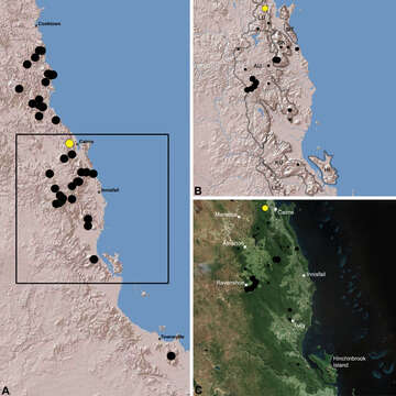
Figure 21.Distribution of Austrarchaea westi sp. n.: A, topographic map showing the known distribution of Archaeidae in the north-eastern Queensland Wet Tropics bioregion, with collection localities for Austrarchaea westi highlighted in yellow; B-C, topographic and satellite maps showing detail of inset (A). Labelled boundaries in (B) denote upland subregional zones of faunal endemism identified by Winter et al. (1984), Williams et al. (1996) and other authors for the central Wet Tropics (modified from Edward 2011). Small squares in (B–C) denote unidentified juvenile specimens; small circles denote unidentified female specimens; large circles denote described species of Austrarchaea. AU = Atherton Uplands; BK = Bellenden Ker/Bartle Frere; HI = Hinchinbrook Island; KU = Kirrama Uplands; LE = Lee Uplands; LU = Lamb Uplands; MT = Malbon-Thompson Uplands.
Included On The Following Pages:
- Life (creatures)
- Cellular (cellular organisms)
- Eukaryota (eukaryotes)
- Opisthokonta (opisthokonts)
- Metazoa (Animal)
- Bilateria
- Protostomia (protostomes)
- Ecdysozoa (ecdysozoans)
- Arthropoda (arthropods)
- Chelicerata (chelicerates)
- Arachnida (arachnids)
- Araneae (spiders)
- Opisthothelae
- Araneomorphae
- Entelegynae
- Archaeidae (pelican spiders)
- Austrarchaea
- Austrarchaea westi
- Panarthropoda
This image is not featured in any collections.
Source Information
- license
- cc-by-3.0
- copyright
- Michael G. Rix, Mark S. Harvey
- bibliographic citation
- Rix M, Harvey M (2012) Australian Assassins, Part III: A review of the Assassin Spiders (Araneae, Archaeidae) of tropical north-eastern Queensland ZooKeys 218: 1–50
- original
- original media file
- visit source
- partner site
- Zookeys
- ID