The Wilderness square - geograph.org.uk - 496445
Description:
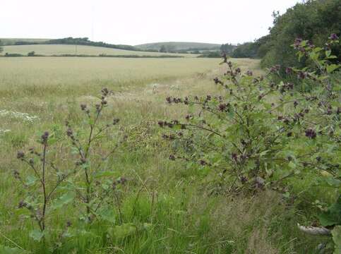
Summary.mw-parser-output table.commons-file-information-table,.mw-parser-output.fileinfotpl-type-information{border:1px solid #a2a9b1;background-color:#f8f9fa;padding:5px;font-size:95%;border-spacing:2px;box-sizing:border-box;margin:0;width:100%}.mw-parser-output table.commons-file-information-table>tbody>tr,.mw-parser-output.fileinfotpl-type-information>tbody>tr{vertical-align:top}.mw-parser-output table.commons-file-information-table>tbody>tr>td,.mw-parser-output table.commons-file-information-table>tbody>tr>th,.mw-parser-output.fileinfotpl-type-information>tbody>tr>td,.mw-parser-output.fileinfotpl-type-information>tbody>tr>th{padding:4px}.mw-parser-output.fileinfo-paramfield{background:#ccf;text-align:right;padding-right:0.4em;width:15%;font-weight:bold}.mw-parser-output.commons-file-information-table+table.commons-file-information-table,.mw-parser-output.commons-file-information-table+div.commons-file-information-table>table{border-top:0;padding-top:0;margin-top:-8px}@media only screen and (max-width:719px){.mw-parser-output table.commons-file-information-table,.mw-parser-output.commons-file-information-table.fileinfotpl-type-information{border-spacing:0;padding:0;word-break:break-word;width:100%!important}.mw-parser-output.commons-file-information-table>tbody,.mw-parser-output.fileinfotpl-type-information>tbody{display:block}.mw-parser-output.commons-file-information-table>tbody>tr>td,.mw-parser-output.commons-file-information-table>tbody>tr>th,.mw-parser-output.fileinfotpl-type-information>tbody>tr>td,.mw-parser-output.fileinfotpl-type-information>tbody>tr>th{padding:0.2em 0.4em;text-align:left;text-align:start}.mw-parser-output.commons-file-information-table>tbody>tr,.mw-parser-output.fileinfotpl-type-information>tbody>tr{display:flex;flex-direction:column}.mw-parser-output.commons-file-information-table+table.commons-file-information-table,.mw-parser-output.commons-file-information-table+div.commons-file-information-table>table{margin-top:-1px}.mw-parser-output.fileinfo-paramfield{box-sizing:border-box;flex:1 0 100%;width:100%}} Description: English: The Wilderness square This is the north-west corner of the square looking north-west. The first 80 metres or so of this picture are in the square and consist of a field of cereal crop, a wide unkept field edge and a hedge line. A bridleway in the adjacent square runs along the first hedge line, but there are no footpaths in this square. Behind me is an impenetrable "jungle" preventing further access. The 1:25K map calls this area, appropriately, The Wilderness. Date: 15 July 2007. Source: From geograph.org.uk. Author: Graham Horn. Attribution(required by the license)InfoFieldGraham Horn / The Wilderness square / CC BY-SA 2.0. InfoFieldGraham Horn / The Wilderness square. Camera location50° 38′ 06″ N, 1° 18′ 26″ W View all coordinates using: OpenStreetMap 50.634870; -1.307300. Object location50° 38′ 07″ N, 1° 18′ 27″ W View all coordinates using: OpenStreetMap 50.635230; -1.307600.
Included On The Following Pages:
- Life
- Cellular
- Eukaryota (eukaryotes)
- Archaeplastida (plants)
- Chloroplastida
- Streptophyta
- Embryophytes
- Tracheophyta
- Spermatophytes (seed plants)
- Angiosperms (Dicotyledons)
- Eudicots
- Superasterids
- Asterids
- Asterales
- Asteraceae (composite family)
- Arctium (burdock)
- Arctium minus (common burdock)
This image is not featured in any collections.
Source Information
- license
- cc-by-sa-3.0
- copyright
- Graham Horn
- creator
- Graham Horn
- source
- From geograph.org.uk
- original
- original media file
- visit source
- partner site
- Wikimedia Commons
- ID