-

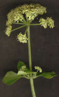
Summary.mw-parser-output table.commons-file-information-table,.mw-parser-output.fileinfotpl-type-information{border:1px solid #a2a9b1;background-color:#f8f9fa;padding:5px;font-size:95%;border-spacing:2px;box-sizing:border-box;margin:0;width:100%}.mw-parser-output table.commons-file-information-table>tbody>tr,.mw-parser-output.fileinfotpl-type-information>tbody>tr{vertical-align:top}.mw-parser-output table.commons-file-information-table>tbody>tr>td,.mw-parser-output table.commons-file-information-table>tbody>tr>th,.mw-parser-output.fileinfotpl-type-information>tbody>tr>td,.mw-parser-output.fileinfotpl-type-information>tbody>tr>th{padding:4px}.mw-parser-output.fileinfo-paramfield{background:#ccf;text-align:right;padding-right:0.4em;width:15%;font-weight:bold}.mw-parser-output.commons-file-information-table+table.commons-file-information-table,.mw-parser-output.commons-file-information-table+div.commons-file-information-table>table{border-top:0;padding-top:0;margin-top:-8px}@media only screen and (max-width:719px){.mw-parser-output table.commons-file-information-table,.mw-parser-output.commons-file-information-table.fileinfotpl-type-information{border-spacing:0;padding:0;word-break:break-word;width:100%!important}.mw-parser-output.commons-file-information-table>tbody,.mw-parser-output.fileinfotpl-type-information>tbody{display:block}.mw-parser-output.commons-file-information-table>tbody>tr>td,.mw-parser-output.commons-file-information-table>tbody>tr>th,.mw-parser-output.fileinfotpl-type-information>tbody>tr>td,.mw-parser-output.fileinfotpl-type-information>tbody>tr>th{padding:0.2em 0.4em;text-align:left;text-align:start}.mw-parser-output.commons-file-information-table>tbody>tr,.mw-parser-output.fileinfotpl-type-information>tbody>tr{display:flex;flex-direction:column}.mw-parser-output.commons-file-information-table+table.commons-file-information-table,.mw-parser-output.commons-file-information-table+div.commons-file-information-table>table{margin-top:-1px}.mw-parser-output.fileinfo-paramfield{box-sizing:border-box;flex:1 0 100%;width:100%}} Description: English: Alexanders by the track. Alexanders (Smyrnium olusatrum) makes an early showing by the track down Stantaway Hill. Date: 7 March 2009. Source: From
geograph.org.uk. Author:
Derek Harper. Attribution(
required by the license)InfoFieldDerek Harper / Alexanders by the track /
CC BY-SA 2.0. InfoFieldDerek Harper / Alexanders by the track. Camera location
50° 28′ 40″ N, 3° 32′ 24″ W View all coordinates using:
OpenStreetMap 50.477800; -3.540000. Object location
50° 28′ 40″ N, 3° 32′ 24″ W View all coordinates using:
OpenStreetMap 50.477800; -3.540000.
-

Summary.mw-parser-output table.commons-file-information-table,.mw-parser-output.fileinfotpl-type-information{border:1px solid #a2a9b1;background-color:#f8f9fa;padding:5px;font-size:95%;border-spacing:2px;box-sizing:border-box;margin:0;width:100%}.mw-parser-output table.commons-file-information-table>tbody>tr,.mw-parser-output.fileinfotpl-type-information>tbody>tr{vertical-align:top}.mw-parser-output table.commons-file-information-table>tbody>tr>td,.mw-parser-output table.commons-file-information-table>tbody>tr>th,.mw-parser-output.fileinfotpl-type-information>tbody>tr>td,.mw-parser-output.fileinfotpl-type-information>tbody>tr>th{padding:4px}.mw-parser-output.fileinfo-paramfield{background:#ccf;text-align:right;padding-right:0.4em;width:15%;font-weight:bold}.mw-parser-output.commons-file-information-table+table.commons-file-information-table,.mw-parser-output.commons-file-information-table+div.commons-file-information-table>table{border-top:0;padding-top:0;margin-top:-8px}@media only screen and (max-width:719px){.mw-parser-output table.commons-file-information-table,.mw-parser-output.commons-file-information-table.fileinfotpl-type-information{border-spacing:0;padding:0;word-break:break-word;width:100%!important}.mw-parser-output.commons-file-information-table>tbody,.mw-parser-output.fileinfotpl-type-information>tbody{display:block}.mw-parser-output.commons-file-information-table>tbody>tr>td,.mw-parser-output.commons-file-information-table>tbody>tr>th,.mw-parser-output.fileinfotpl-type-information>tbody>tr>td,.mw-parser-output.fileinfotpl-type-information>tbody>tr>th{padding:0.2em 0.4em;text-align:left;text-align:start}.mw-parser-output.commons-file-information-table>tbody>tr,.mw-parser-output.fileinfotpl-type-information>tbody>tr{display:flex;flex-direction:column}.mw-parser-output.commons-file-information-table+table.commons-file-information-table,.mw-parser-output.commons-file-information-table+div.commons-file-information-table>table{margin-top:-1px}.mw-parser-output.fileinfo-paramfield{box-sizing:border-box;flex:1 0 100%;width:100%}} Description: English: Alexanders, Smyrnium olusatrum A common weed throughout the area, also known as Hedge Parsley. Date: 24 March 2008. Source: From
geograph.org.uk. Author:
Nick Smith. Attribution(
required by the license)InfoFieldNick Smith / Alexanders, Smyrnium olusatrum /
CC BY-SA 2.0. InfoFieldNick Smith / Alexanders, Smyrnium olusatrum. Camera location
51° 20′ 43″ N, 1° 19′ 01″ E View all coordinates using:
OpenStreetMap 51.345220; 1.317000. Object location
51° 20′ 42″ N, 1° 19′ 00″ E View all coordinates using:
OpenStreetMap 51.345130; 1.316800.
-

Summary.mw-parser-output table.commons-file-information-table,.mw-parser-output.fileinfotpl-type-information{border:1px solid #a2a9b1;background-color:#f8f9fa;padding:5px;font-size:95%;border-spacing:2px;box-sizing:border-box;margin:0;width:100%}.mw-parser-output table.commons-file-information-table>tbody>tr,.mw-parser-output.fileinfotpl-type-information>tbody>tr{vertical-align:top}.mw-parser-output table.commons-file-information-table>tbody>tr>td,.mw-parser-output table.commons-file-information-table>tbody>tr>th,.mw-parser-output.fileinfotpl-type-information>tbody>tr>td,.mw-parser-output.fileinfotpl-type-information>tbody>tr>th{padding:4px}.mw-parser-output.fileinfo-paramfield{background:#ccf;text-align:right;padding-right:0.4em;width:15%;font-weight:bold}.mw-parser-output.commons-file-information-table+table.commons-file-information-table,.mw-parser-output.commons-file-information-table+div.commons-file-information-table>table{border-top:0;padding-top:0;margin-top:-8px}@media only screen and (max-width:719px){.mw-parser-output table.commons-file-information-table,.mw-parser-output.commons-file-information-table.fileinfotpl-type-information{border-spacing:0;padding:0;word-break:break-word;width:100%!important}.mw-parser-output.commons-file-information-table>tbody,.mw-parser-output.fileinfotpl-type-information>tbody{display:block}.mw-parser-output.commons-file-information-table>tbody>tr>td,.mw-parser-output.commons-file-information-table>tbody>tr>th,.mw-parser-output.fileinfotpl-type-information>tbody>tr>td,.mw-parser-output.fileinfotpl-type-information>tbody>tr>th{padding:0.2em 0.4em;text-align:left;text-align:start}.mw-parser-output.commons-file-information-table>tbody>tr,.mw-parser-output.fileinfotpl-type-information>tbody>tr{display:flex;flex-direction:column}.mw-parser-output.commons-file-information-table+table.commons-file-information-table,.mw-parser-output.commons-file-information-table+div.commons-file-information-table>table{margin-top:-1px}.mw-parser-output.fileinfo-paramfield{box-sizing:border-box;flex:1 0 100%;width:100%}} Description: English: Alexanders at Harlyn Bay The herb Alexanders growing in profusion beside the coast path west of Harlyn Bay. Date: 30 April 2009. Source: From
geograph.org.uk. Author:
Andy F. Attribution(
required by the license)InfoFieldAndy F / Alexanders at Harlyn Bay /
CC BY-SA 2.0. InfoFieldAndy F / Alexanders at Harlyn Bay. Camera location
50° 32′ 39″ N, 5° 00′ 16″ W View all coordinates using:
OpenStreetMap 50.544110; -5.004400. Object location
50° 32′ 39″ N, 5° 00′ 14″ W View all coordinates using:
OpenStreetMap 50.544120; -5.003900.
-

Summary.mw-parser-output table.commons-file-information-table,.mw-parser-output.fileinfotpl-type-information{border:1px solid #a2a9b1;background-color:#f8f9fa;padding:5px;font-size:95%;border-spacing:2px;box-sizing:border-box;margin:0;width:100%}.mw-parser-output table.commons-file-information-table>tbody>tr,.mw-parser-output.fileinfotpl-type-information>tbody>tr{vertical-align:top}.mw-parser-output table.commons-file-information-table>tbody>tr>td,.mw-parser-output table.commons-file-information-table>tbody>tr>th,.mw-parser-output.fileinfotpl-type-information>tbody>tr>td,.mw-parser-output.fileinfotpl-type-information>tbody>tr>th{padding:4px}.mw-parser-output.fileinfo-paramfield{background:#ccf;text-align:right;padding-right:0.4em;width:15%;font-weight:bold}.mw-parser-output.commons-file-information-table+table.commons-file-information-table,.mw-parser-output.commons-file-information-table+div.commons-file-information-table>table{border-top:0;padding-top:0;margin-top:-8px}@media only screen and (max-width:719px){.mw-parser-output table.commons-file-information-table,.mw-parser-output.commons-file-information-table.fileinfotpl-type-information{border-spacing:0;padding:0;word-break:break-word;width:100%!important}.mw-parser-output.commons-file-information-table>tbody,.mw-parser-output.fileinfotpl-type-information>tbody{display:block}.mw-parser-output.commons-file-information-table>tbody>tr>td,.mw-parser-output.commons-file-information-table>tbody>tr>th,.mw-parser-output.fileinfotpl-type-information>tbody>tr>td,.mw-parser-output.fileinfotpl-type-information>tbody>tr>th{padding:0.2em 0.4em;text-align:left;text-align:start}.mw-parser-output.commons-file-information-table>tbody>tr,.mw-parser-output.fileinfotpl-type-information>tbody>tr{display:flex;flex-direction:column}.mw-parser-output.commons-file-information-table+table.commons-file-information-table,.mw-parser-output.commons-file-information-table+div.commons-file-information-table>table{margin-top:-1px}.mw-parser-output.fileinfo-paramfield{box-sizing:border-box;flex:1 0 100%;width:100%}} Description: English: Smyrnium olusatrum in Massif de la Clape, Aude, France. Date: 4 April 2022, 11:50:30. Source: Own work. Author:
Krzysztof Golik. Camera location
43° 10′ 05.98″ N, 3° 07′ 58.88″ E View all coordinates using:
OpenStreetMap 43.168327; 3.133022.
-
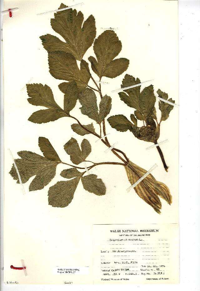
Herbarium Specimen..
-
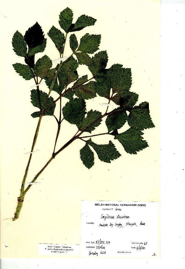
Herbarium Specimen..
-
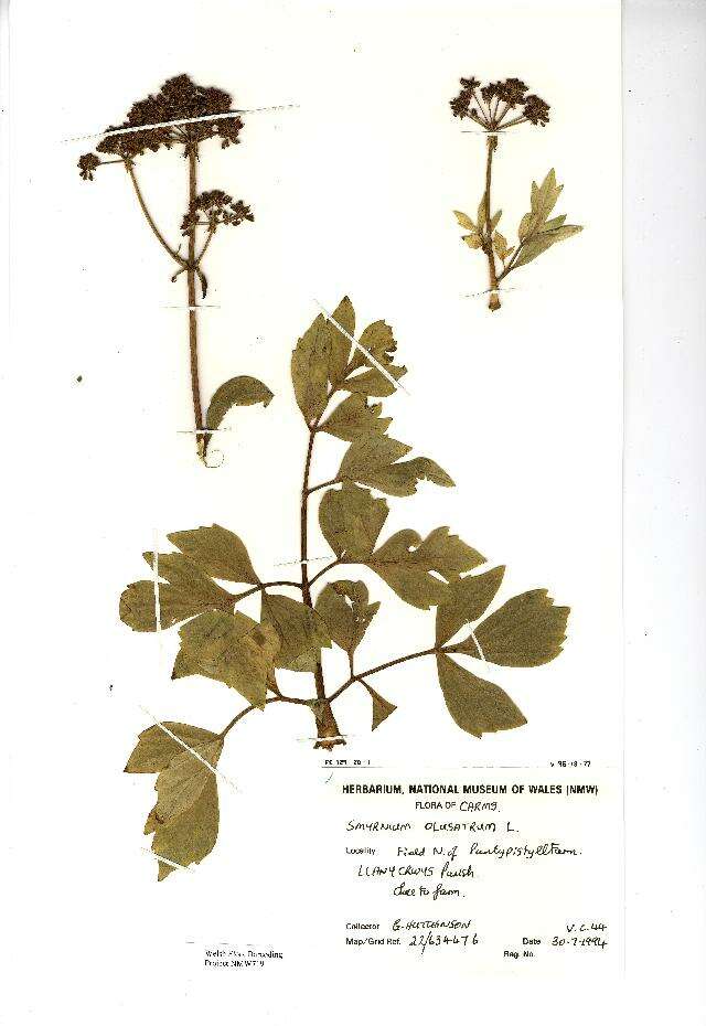
Herbarium Specimen..
-
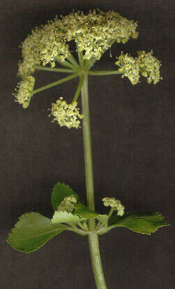
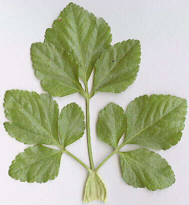
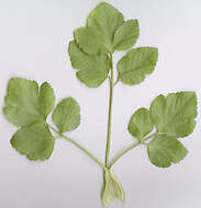
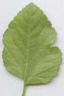
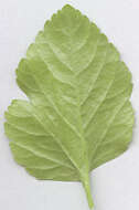
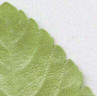
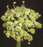
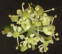
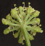
Longitude (deg): -1.1. Latitude (deg): 51.4. Longitude (deg/min): 1° 10' W. Latitude (deg/min): 51° 30' N. Vice county name: Berks. Vice county no.: 22. Country: England. Stage: Plant. Identified by: Malcolm Storey. Photo summary: "cauline leaf, umbel, leaf texture and margin, pollen". Category: macro-photograph. Real world width(mm): 63.754. Photographic equipment used: Specimens directly scanned on Black Widow 9630 SP flatbed scanner.
-
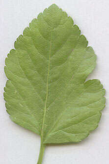
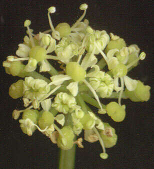
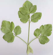
Longitude (deg): -1.1. Latitude (deg): 51.4. Longitude (deg/min): 1° 10' W. Latitude (deg/min): 51° 30' N. Vice county name: Berks. Vice county no.: 22. Country: England. Stage: Plant. Identified by: Malcolm Storey. Photo summary: "cauline leaf, umbel, leaf texture and margin, pollen". Category: macro-photograph. Real world width(mm): 195.4388888889. Photographic equipment used: Specimens directly scanned on Black Widow 9630 SP flatbed scanner.
-
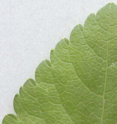
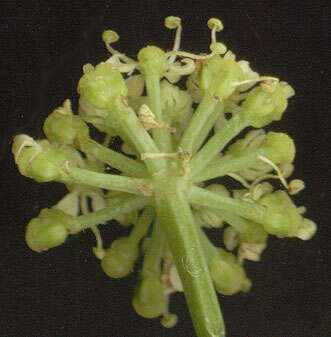
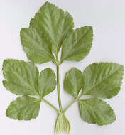
Longitude (deg): -1.1. Latitude (deg): 51.4. Longitude (deg/min): 1° 10' W. Latitude (deg/min): 51° 30' N. Vice county name: Berks. Vice county no.: 22. Country: England. Stage: Plant. Identified by: Malcolm Storey. Photo summary: "cauline leaf, umbel, leaf texture and margin, pollen". Category: macro-photograph. Real world width(mm): 195.0861111111. Photographic equipment used: Specimens directly scanned on Black Widow 9630 SP flatbed scanner.
-
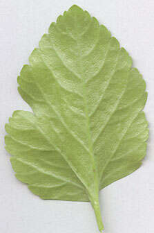
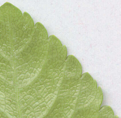
Longitude (deg): -1.1. Latitude (deg): 51.4. Longitude (deg/min): 1° 10' W. Latitude (deg/min): 51° 30' N. Vice county name: Berks. Vice county no.: 22. Country: England. Stage: Plant. Identified by: Malcolm Storey. Photo summary: "cauline leaf, umbel, leaf texture and margin, pollen". Category: macro-photograph. Real world width(mm): 132.9972222222. Photographic equipment used: Specimens directly scanned on Black Widow 9630 SP flatbed scanner.
-
Longitude (deg): -1.1. Latitude (deg): 51.4. Longitude (deg/min): 1° 10' W. Latitude (deg/min): 51° 30' N. Vice county name: Berks. Vice county no.: 22. Country: England. Stage: Plant. Identified by: Malcolm Storey. Photo summary: "cauline leaf, umbel, leaf texture and margin, pollen". Category: macro-photograph. Real world width(mm): 37.592. Photographic equipment used: Specimens directly scanned on Black Widow 9630 SP flatbed scanner.
-
Longitude (deg): -1.1. Latitude (deg): 51.4. Longitude (deg/min): 1° 10' W. Latitude (deg/min): 51° 30' N. Vice county name: Berks. Vice county no.: 22. Country: England. Stage: Plant. Identified by: Malcolm Storey. Photo summary: "cauline leaf, umbel, leaf texture and margin, pollen". Category: macro-photograph. Real world width(mm): 16.42533333333. Photographic equipment used: Specimens directly scanned on Black Widow 9630 SP flatbed scanner.
-
Longitude (deg): -1.1. Latitude (deg): 51.4. Longitude (deg/min): 1° 10' W. Latitude (deg/min): 51° 30' N. Vice county name: Berks. Vice county no.: 22. Country: England. Stage: Plant. Identified by: Malcolm Storey. Photo summary: "cauline leaf, umbel, leaf texture and margin, pollen". Category: macro-photograph. Real world width(mm): 37.76133333333. Photographic equipment used: Specimens directly scanned on Black Widow 9630 SP flatbed scanner.
-
Longitude (deg): -1.1. Latitude (deg): 51.4. Longitude (deg/min): 1° 10' W. Latitude (deg/min): 51° 30' N. Vice county name: Berks. Vice county no.: 22. Country: England. Stage: Plant. Identified by: Malcolm Storey. Photo summary: "cauline leaf, umbel, leaf texture and margin, pollen". Category: macro-photograph. Real world width(mm): 17.86466666667. Photographic equipment used: Specimens directly scanned on Black Widow 9630 SP flatbed scanner.
-
Longitude (deg): -1.1. Latitude (deg): 51.4. Longitude (deg/min): 1° 10' W. Latitude (deg/min): 51° 30' N. Vice county name: Berks. Vice county no.: 22. Country: England. Stage: Plant. Identified by: Malcolm Storey. Photo summary: "cauline leaf, umbel, leaf texture and margin, pollen". Category: macro-photograph. Real world width(mm): 13.03866666667. Photographic equipment used: Specimens directly scanned on Black Widow 9630 SP flatbed scanner.
-
Longitude (deg): -1.1. Latitude (deg): 51.4. Longitude (deg/min): 1° 10' W. Latitude (deg/min): 51° 30' N. Vice county name: Berks. Vice county no.: 22. Country: England. Stage: Plant. Identified by: Malcolm Storey. Photo summary: "cauline leaf, umbel, leaf texture and margin, pollen". Category: macro-photograph. Real world width(mm): 13.589. Photographic equipment used: Specimens directly scanned on Black Widow 9630 SP flatbed scanner.
-
Longitude (deg): -1.1. Latitude (deg): 51.4. Longitude (deg/min): 1° 10' W. Latitude (deg/min): 51° 30' N. Vice county name: Berks. Vice county no.: 22. Country: England. Stage: Plant. Identified by: Malcolm Storey. Photo summary: "cauline leaf, umbel, leaf texture and margin, pollen". Category: macro-photograph. Real world width(mm): 14.01233333333. Photographic equipment used: Specimens directly scanned on Black Widow 9630 SP flatbed scanner.
-
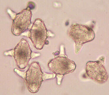
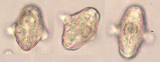
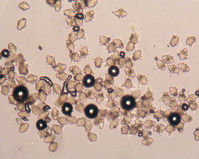
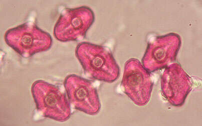
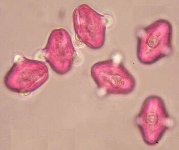
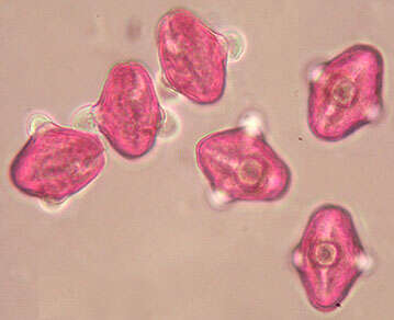
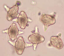
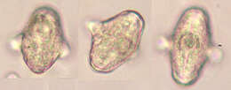
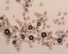
Longitude (deg): -1.1. Latitude (deg): 51.4. Longitude (deg/min): 1° 10' W. Latitude (deg/min): 51° 30' N. Vice county name: Berks. Vice county no.: 22. Country: England. Stage: Plant. Identified by: Malcolm Storey. Photo summary: "cauline leaf, umbel, leaf texture and margin, pollen". Category: microscope photograph. Image scaling: magnified. Photographic equipment used: Pixera Pro tethered low-resolution digital camera with Meiji microscope using CS adaptor and x.7 projection eye-piece.
-
Longitude (deg): -1.1. Latitude (deg): 51.4. Longitude (deg/min): 1° 10' W. Latitude (deg/min): 51° 30' N. Vice county name: Berks. Vice county no.: 22. Country: England. Stage: Plant. Identified by: Malcolm Storey. Photo summary: "cauline leaf, umbel, leaf texture and margin, pollen". Category: microscope photograph. Image scaling: magnified. Photographic equipment used: Pixera Pro tethered low-resolution digital camera with Meiji microscope using CS adaptor and x.7 projection eye-piece.